You don’t need to rent a car to see Seattle. That’s the myth that costs many visitors extra money, parking headaches, and unnecessary stress before they even reach Pike Place Market. With seattle transportation options explained clearly, you’ll find a city that’s genuinely well-connected by light rail, buses, ferries, rideshares, and water taxis, all working together to get you where you want to go. Whether you’re arriving at Sea-Tac Airport with two suitcases or hopping between waterfront attractions on a sunny afternoon, Seattle’s transit network covers far more ground than most first-time visitors expect.
Table of Contents
- Key takeaways
- Seattle transportation options explained: the agencies behind the network
- Link light rail: your fastest ride from the airport
- Bus networks and RapidRide: reaching every neighborhood
- Ferries, water taxis, and the Seattle Streetcar
- Rideshares, taxis, and when a car rental actually makes sense
- My take on what visitors consistently get wrong about Seattle transit
- Explore Seattle with West Coast Tour Partners
- FAQ
Key takeaways
| Point | Details |
|---|---|
| Skip the rental car downtown | Public transit and rideshare cover major attractions cost-effectively for most visitors staying downtown. |
| Get an ORCA card immediately | One tap-and-go card works across buses, light rail, ferries, and streetcar for a unified fare experience. |
| Light rail beats rideshare from the airport | The Link light rail runs every 8 to 10 minutes and gets you downtown in about 38 minutes for just $3. |
| Three agencies run Seattle’s transit | King County Metro, Sound Transit, and Washington State Ferries each control different parts of the network. |
| Ferries are more than transportation | Water routes to Bainbridge Island and West Seattle double as scenic Seattle experiences worth planning around. |
Seattle transportation options explained: the agencies behind the network
Before you plan a single trip, you need to understand one thing that confuses almost every first-time visitor: Seattle’s transit system is not one unified operation. Three separate agencies share responsibility, and knowing which agency does what saves you real confusion when you’re reading schedules or buying tickets.
Here’s how the system breaks down:
- King County Metro operates the city’s bus network, covering hundreds of routes across Seattle and the surrounding region. Metro also runs the Water Taxi service connecting downtown Seattle to West Seattle and Vashon Island.
- Sound Transit runs Link light rail, Sounder commuter trains, and ST Express regional bus routes. If you’re taking the train from Sea-Tac Airport into the city, that’s a Sound Transit service.
- Washington State Ferries manages water crossings, including the beloved Seattle to Bainbridge Island route and dozens of other island and peninsula connections across Puget Sound.
The layered nature of these agencies matters more than it might seem. Seattle’s transit jurisdiction structure means that changes to bus routes require Metro approval, while station access improvements involve the Seattle Department of Transportation separately. For you as a visitor, the practical takeaway is simple: use the right app for the right agency. Google Maps handles most multi-modal trip planning, but Sound Transit’s own app offers better real-time tracking for light rail, and the WSF app is the most reliable source for ferry schedules.
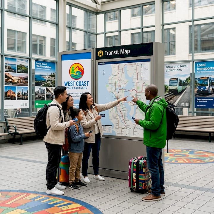
The glue that holds all of this together is the ORCA card. Short for One Regional Card for All, this reloadable smart card works on King County Metro buses, Sound Transit light rail and buses, Washington State Ferries passenger service, and the Seattle Streetcar. You can load it at vending machines in any Link station or purchase one online. The card automatically applies the best available transfer discount, which means you’re not paying full fare every time you switch between a bus and a train.
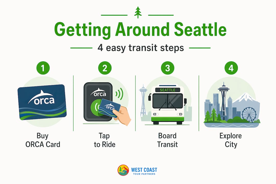
Pro Tip: Purchase your ORCA card at the Sea-Tac Airport Link station before leaving the airport. You’ll step off your flight and be able to tap onto the light rail immediately without digging for cash or figuring out a ticket machine under pressure.
Link light rail: your fastest ride from the airport
For most visitors flying into Sea-Tac, Link light rail is the single best first move you can make. The 1 Line connects Sea-Tac Airport directly to downtown Seattle’s Westlake Station, running every 8 to 10 minutes with a total travel time of approximately 38 minutes. Compare that to a rideshare, which can run 45 to 75 minutes during afternoon peak hours while costing $45 to $65 or more, and the choice becomes obvious.
The fare structure makes light rail even more attractive:
| Passenger Type | One-Way Fare |
|---|---|
| Adult (standard fare) | $3.00 |
| Youth (18 and under) | Free |
| Senior / Disabled / ORCA Lift | $1.00 |
The 1 Line doesn’t just serve the airport. It also stops at Capitol Hill, the University of Washington, and several South Seattle neighborhoods, making it genuinely useful for exploring beyond the downtown core. Riders heading to Capitol Hill for dinner or to the University District for a game can use the same line they rode from the airport, no transfers needed.
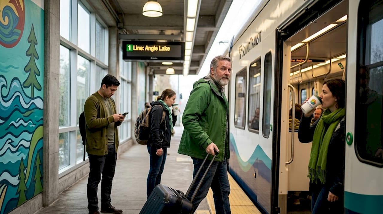
Light rail works best for visitors who are traveling solo or with compact luggage, moving between the airport and downtown, heading to Capitol Hill or the University District, or looking for a predictable, weather-protected commute. The trains are clean, air-conditioned, and run on a consistent schedule that doesn’t change based on traffic.
Pro Tip: If you’re traveling with a large group or have multiple checked bags, the light rail is still worth considering. Trains have designated luggage areas near the doors, and you won’t be charged per bag the way some shuttle services work.
Bus networks and RapidRide: reaching every neighborhood
Light rail covers the major spine of the city, but Seattle’s buses fill in everything else. King County Metro’s bus network is extensive, with routes reaching Pioneer Square, Fremont, Ballard, Georgetown, and neighborhoods well outside the downtown core. For tourists who want to explore beyond the waterfront, buses are often the most direct option.
Within the Metro system, RapidRide routes are worth knowing specifically. These high-frequency lines make fewer stops, operate more like light rail in terms of reliability, and accept ORCA card tap payments at off-board stations before you board, which speeds up loading significantly. The most useful RapidRide lines for visitors include:
- RapidRide C Line: Connects downtown to West Seattle, passing through the Delridge neighborhood.
- RapidRide D Line: Runs from downtown through Uptown (near the Space Needle) to Ballard, making it genuinely practical for tourists visiting Seattle Center or looking for Ballard’s restaurant scene.
- RapidRide E Line: Heads north along Aurora Avenue toward Shoreline, serving areas not on the light rail line.
- RapidRide G Line: Covers Madison Street between downtown and the Madison Valley neighborhood.
For reading schedules and finding stops, the One Bus Away app is the most popular tool among Seattle locals. It shows real-time arrivals at any stop and lets you save your most-used routes. Google Maps also handles Metro routing well, though One Bus Away gives you more granular real-time data when you’re standing at a stop in the rain.
Fares on Metro buses are $2.75 for adults, with youth under 18 riding free and reduced fares available for qualifying riders. Your ORCA card handles the transfer discount automatically when you move between a bus and light rail within two hours.
Ferries, water taxis, and the Seattle Streetcar
Seattle sits on Puget Sound, and that geography shapes transportation in ways that no other major American city quite replicates. Water transit here is not a novelty. It’s a practical, scenic, and often surprisingly fast way to get around.
Washington State Ferries runs the Seattle to Bainbridge Island route from Colman Dock at Pier 52, departing roughly every 35 to 60 minutes depending on the time of day. The crossing takes about 35 minutes and offers views of the Seattle skyline and the Olympic Mountains that are genuinely hard to match. Passenger-only fares are affordable, and youth riders travel free.
Here’s a quick look at water transit options and when to use each:
| Service | Route | Best For |
|---|---|---|
| Washington State Ferries | Seattle to Bainbridge Island | Day trips, scenic views, island exploration |
| King County Water Taxi | Downtown to West Seattle | Faster West Seattle access, avoiding bridge traffic |
| King County Water Taxi | Downtown to Vashon Island | Weekend day trips and scenic travel |
| Seattle Streetcar | South Lake Union and First Hill | Short urban trips near hotels and Pike Place Market |
The Seattle Streetcar operates on two lines: the South Lake Union line and the First Hill line. Neither covers huge distances, but both connect neighborhoods where many visitors stay and eat. If you’re heading from Pike Place Market toward South Lake Union’s tech-district restaurants, the South Lake Union Streetcar line is a comfortable, low-effort option that accepts ORCA cards.
Pro Tip: The King County Water Taxi to West Seattle is often faster than driving during peak hours, especially with ongoing bridge construction affecting traffic patterns. Check the Water Taxi schedule in advance since sailings are less frequent than bus service.
Rideshares, taxis, and when a car rental actually makes sense
Uber and Lyft both operate widely in Seattle, and for certain situations, they’re genuinely the right choice. Late-night travel, trips carrying gear or groceries, and journeys to neighborhoods poorly served by transit all make sense for rideshare. The problem is timing. I-5 congestion patterns have shifted so that the worst southbound peak now hits after 8:45 a.m., which means a rideshare that looks reasonable at 8:30 a.m. can become a slow, expensive crawl by the time you’re picked up.
Here are the situations where rideshare makes the most sense:
- Late-night travel when bus frequency drops significantly after 10:00 p.m.
- Airport drop-off when you’re checking in early and want door-to-door convenience.
- Group travel where splitting a fare brings the cost below light rail for multiple people.
- Neighborhoods without rail such as Fremont, Magnolia, or Beacon Hill areas not directly on the 1 Line.
- Event day logistics when transit is running but you have specific timing constraints.
On the topic of airports: Sea-Tac’s expressway experiences severe congestion during peak pickup and drop-off times. The airport operates a dedicated Cell Phone Lot with free parking and Wi-Fi for rideshare drivers waiting for passengers. If you’re being picked up, expect your driver to be there rather than circling, and build in extra time.
For FIFA World Cup 2026, Seattle and regional transit planners have set a goal of 80% of fans using public transit to reach games, including a free Waterfront Shuttle connecting major tourist hubs. That’s an ambitious target that signals real investment in making transit the default, not the backup.
Car rentals are worth it only if you’re planning day trips outside the city to places like Snoqualmie Falls, Mount Rainier, or the wine country east of the Cascades. Downtown Seattle parking runs $30 to $50 per day in garages near Pike Place, and traffic makes driving genuinely slower than the combination of light rail and walking for most tourist itineraries.
Pro Tip: If you do rent a car, pick it up on the day you actually need it for a road trip rather than keeping it for your entire stay. You’ll save on parking costs and avoid the temptation to drive short distances that are faster and cheaper by rail.
My take on what visitors consistently get wrong about Seattle transit
I’ve watched visitor after visitor arrive in Seattle convinced they need a car, then spend their first day fighting for parking near Pike Place Market while light rail glided past outside. The honest truth is that multi-modal trip planning sounds complicated but is actually simpler in Seattle than in most cities its size, once you understand that three agencies handle different pieces of the same puzzle.
The biggest mistake isn’t skipping the ORCA card. It’s not knowing that the agencies overlap. A visitor who doesn’t realize Sound Transit and King County Metro are separate operations ends up confused when a Sound Transit route doesn’t appear in the Metro app, or when a ferry fare isn’t covered by a Metro pass. Understanding the institutional structure behind the transit system is what turns a frustrating first day into a smooth one.
What I’ve found most useful is building your itinerary around transit rather than treating transit as an afterthought. If you’re staying near a Link station, your airport arrival, your Space Needle visit, and your Capitol Hill dinner are all covered without a single rideshare. The ferry to Bainbridge isn’t just a crossing. It’s genuinely one of the best views of Seattle you’ll find anywhere, and it costs less than a coffee at the tourist spots on the waterfront. The system rewards curiosity.
— WCTP_Systems
Explore Seattle with West Coast Tour Partners
Knowing how to get around Seattle is one thing. Knowing what to do when you arrive is where the real adventure starts.

West Coast Tour Partners brings Seattle’s neighborhoods, waterfront, and hidden history to life through immersive, story-driven experiences designed specifically for visitors and cruise passengers. From the entertaining Let’s Go Seattle! Shuttle that combines city orientation with live storytelling and humor, to the iconic Market Experience at Pike Place Market featuring scavenger hunts, local tastings, and hidden-history discoveries, every WCTP experience is built to feel like something you’ll actually remember. Whether you’ve just stepped off a cruise ship or you’re planning a few days in the city, West Coast Tour Partners makes sure your time in Seattle goes well beyond the ordinary.
FAQ
What is the cheapest way to get from Sea-Tac Airport to downtown Seattle?
Link light rail is the most affordable option, with an adult fare of $3 and free rides for youth 18 and under. The trip takes approximately 38 minutes and runs every 8 to 10 minutes.
Do I need an ORCA card as a tourist in Seattle?
You don’t absolutely need one, but it makes travel significantly easier. The ORCA card works across buses, light rail, ferries, and streetcar, and it applies transfer discounts automatically when you switch between services within two hours.
Is public transit in Seattle good enough to skip renting a car?
For most visitors staying downtown, yes. Public transit and rideshare together cover Seattle’s major attractions without the added cost of parking, which runs $30 to $50 per day near popular tourist areas. A rental car only makes practical sense for day trips outside the city.
How do Washington State Ferries work for tourists?
Ferries depart from Colman Dock at Pier 52 and connect Seattle to Bainbridge Island, Bremerton, and other destinations across Puget Sound. Passenger fares are modest, youth ride free, and the Bainbridge Island crossing is one of the most scenic 35-minute rides you can take anywhere on the West Coast.
What transit changes should visitors expect during FIFA World Cup 2026?
Seattle’s regional transit plan for the World Cup targets 80% fan transit use, with a free Waterfront Shuttle added to connect major tourist hubs. Expect higher ridership on all transit lines and plan accordingly by traveling earlier than usual during match days.
Leave a Reply